Determining inflow and outflow and levelling by group VI
The course of ENVIRONMENTAL FIELD WORK continued first time outdoors, on 19th of September. Our jolly group was formed by third year students; four from China, Wangqing Chen, Xingue Wang, Wenqi Zhang, Qiuwang Fan, one from Germany, Julia Schmidt and I, Jani Paukkonen, a local chap.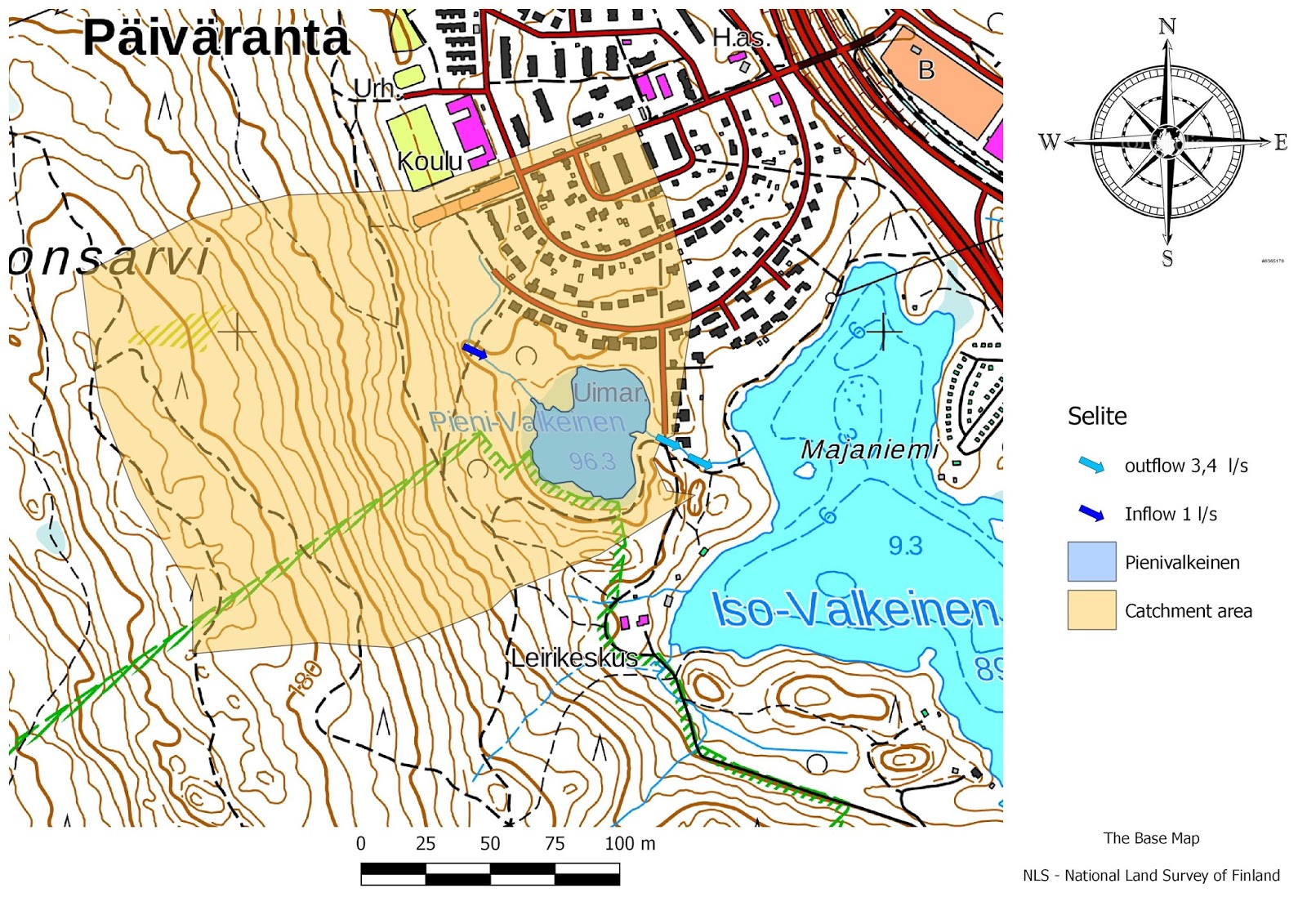 |
| Picture 1. Thematic map of Pieni-Valkeinen |
Levelling


The green plastic sheet was rather challenging to set on the stream without letting any water to flow aside or underneath. This is, in fact, one of the the major reasons why our flowrates can not be considered accurate. By V-dam, our result for outflow of the lake Pieni-Valkeinen was 3,8 l/s and by volumetric method, the outflow was 3,4 l/s. Volumetric measuring was implemented at the rainwater drum. The idea behind this was was simply to see how much time does it take to fill the bucket. This was repeated four times to get estimation of the average outflow of the lake, Pieni-Valkeinen. Chart 2.
(chart2.)

For the inflow for the Pieni-Valkeinen our result was 1,0 l/s and this was left the only result for the inflow, because we were not capable to find free fall of stream, high enough to set bucket underneath.
There is a remarkable difference between inflow and outflow of the Pieni- Valkeinen. Our team came into the conclusion, that the stream in which our measurement was performed, is not the only source of water for the Pieni-Valkeinen. Precipitation must flow in a wide range of the catchment area of the Pieni-Valkeinen, and this flow do not always leave a visible trace/stream on the surface.
This was excellent task, because the results raised a new questions and challenged us to study reasons for: "how come outflow can be bigger than inflow"!
One another thing we learned, that these experiments on the field require TIME!
Thank you for nice report. You have used leveling device successfully and set record value for the measurement error. You got 0,16 m difference between starting point and ending point, when you solve current water level of Iso-Valkeinen lake.
VastaaPoistaLet's have competion between groups, I will give special prize for the group who has minimun error at the end of course!
Would you present the final results of discharge measurements in a one concluding table at the end of this report? This would help reader to find most important values.
Nice question, "How come outflow can be bigger than inflow?". I think this is one of the main questions which we have realize during this course. I think natural water cycle (hydrologic cycle) gives answer for that, maybe you should explore that a little...
Teemu
I agree with your conclusion, moreover there is also groundwater included.
VastaaPoistaTeemu